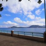
The Cape D’Aguilar Marine Reserve is located at the southeastern tip of Hong Kong Island. Its eastern boundary extends from Shuangsimen to the eastern shore end of Cape D’Aguilar and then southward to the southeastern tip of Kau Pei Chau. The western boundary extends from the rocky promontory opposite the radio transmission station to the southern tip of Kau Pei Chau. The purpose of establishing the marine reserve is to protect marine resources for scientific research and educate the public to cherish precious marine resources.
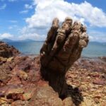
To protect the important organisms and their environment in the marine reserve, except for approved scientific research activities, general water and coastal recreational activities such as swimming, boating, fishing or collecting wild animals and plants are not allowed in the marine reserve. Around the Cape D’Aguilar Marine Reserve, four main types of rocks can be found. Calculated by the age of rock formation, the older one is tuff formed by volcanic eruptions, followed by granodiorite, rhyolitic porphyry and basalt. In terms of landforms, there are rocky shores impacted by wind and waves in the marine reserve, which are common landforms at capes and headlands on the southeastern side of Hong Kong. The steep granite shore is rugged and irregularly stepped, with vertical surfaces up to one meter high and narrow rock ledges. When waves surge in, temporary small pools will form. The biodiversity in the Cape D’Aguilar Marine Reserve is quite rich, including various fishes, scleractinian corals, soft corals, gorgonians and marine invertebrates. As an internet-famous photography holy land, the Cape D’Aguilar Marine Reserve is known as the ‘Eye of God’. The opening hours are all year round and open all day. The specific business status is subject to the opening situation on that day.Cape D’Aguilar
The Cape D’Aguilar Marine Reserve is located at the southeastern tip of Hong Kong Island. Its [...]